Page 30 of 46
Re: The Unusual Maps Thread
Posted: Wed Apr 11, 2018 12:38 pm
by Taranaki Snapper
Re: The Unusual Maps Thread
Posted: Sun Apr 15, 2018 1:58 pm
by Taranaki Snapper
?
Re: The Unusual Maps Thread
Posted: Tue Apr 17, 2018 12:50 am
by Taranaki Snapper
Ten Mesmerizing Geophysical Maps That Double as Works of Art
https://eos.org/features/ten-mesmerizin ... rks-of-art
Re: The Unusual Maps Thread
Posted: Tue Apr 17, 2018 4:08 pm
by DonBillydeParis
Re: The Unusual Maps Thread
Posted: Tue Apr 17, 2018 5:10 pm
by Flyin Ryan
I can't put the maps up here, but my grandfather died recently and prior to the funeral we were going through his old stuff. He was drafted and served in the German post-war occupation force in the Army in the 1950s. While there he did some travel to England and France, and he had the tour maps in the books for London and Paris good down to the street level. I looked for a date on them, one wasn't listed, but I have to imagine they were early-to-mid-1950s publish date. The London maps were scaled in inches to miles. They're such I was thinking of asking my grandmother for them and maybe arrange them up in a frame to hang up.
Re: The Unusual Maps Thread
Posted: Sat Apr 21, 2018 5:13 pm
by Lacrobat
Re: The Unusual Maps Thread
Posted: Sat Apr 21, 2018 5:14 pm
by Lacrobat
Re: The Unusual Maps Thread
Posted: Sat Apr 21, 2018 5:47 pm
by Lacrobat
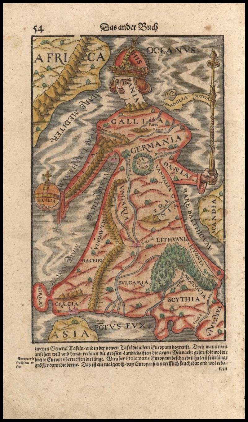
The Roman Empire as a TV Show:
Re: The Unusual Maps Thread
Posted: Thu Apr 26, 2018 10:37 pm
by Nieghorn
Was just weeding some very old books from the library that haven't been checked out since the 80s and found this wonderful map of Wolfe's Quebec campaign ... scanned it large, so:
https://imgur.com/V4Wi4S6
Re: The Unusual Maps Thread
Posted: Fri Apr 27, 2018 2:36 am
by Pat the Ex Mat
The No response for North Wales should of course be:
"Chips a Cwri saws"
Re: The Unusual Maps Thread
Posted: Thu May 03, 2018 12:16 pm
by Nolanator
10 respondents for NI. Gravy being the favourite for Antrim isalmost certainly due to a couple of people loving the gravy chips from the Sphinx.
I know I do.

Re: The Unusual Maps Thread
Posted: Thu May 03, 2018 12:43 pm
by etherman
Nolanator wrote:
10 respondents for NI. Gravy being the favourite for Antrim isalmost certainly due to a couple of people loving the gravy chips from the Sphinx.
I know I do.
Are you mad? The Sphinx house sauce is nectar of the gods. And their Currys amazing too. You've been picking the fat one from Little Mix.
Re: The Unusual Maps Thread
Posted: Thu May 03, 2018 12:49 pm
by Nolanator
I started working my way down the list, but liked the first one I chose so much that I never progressed past it.
Too late now.
Good excuse to go back for a visit, though.
Re: The Unusual Maps Thread
Posted: Thu May 10, 2018 10:22 pm
by Lacrobat
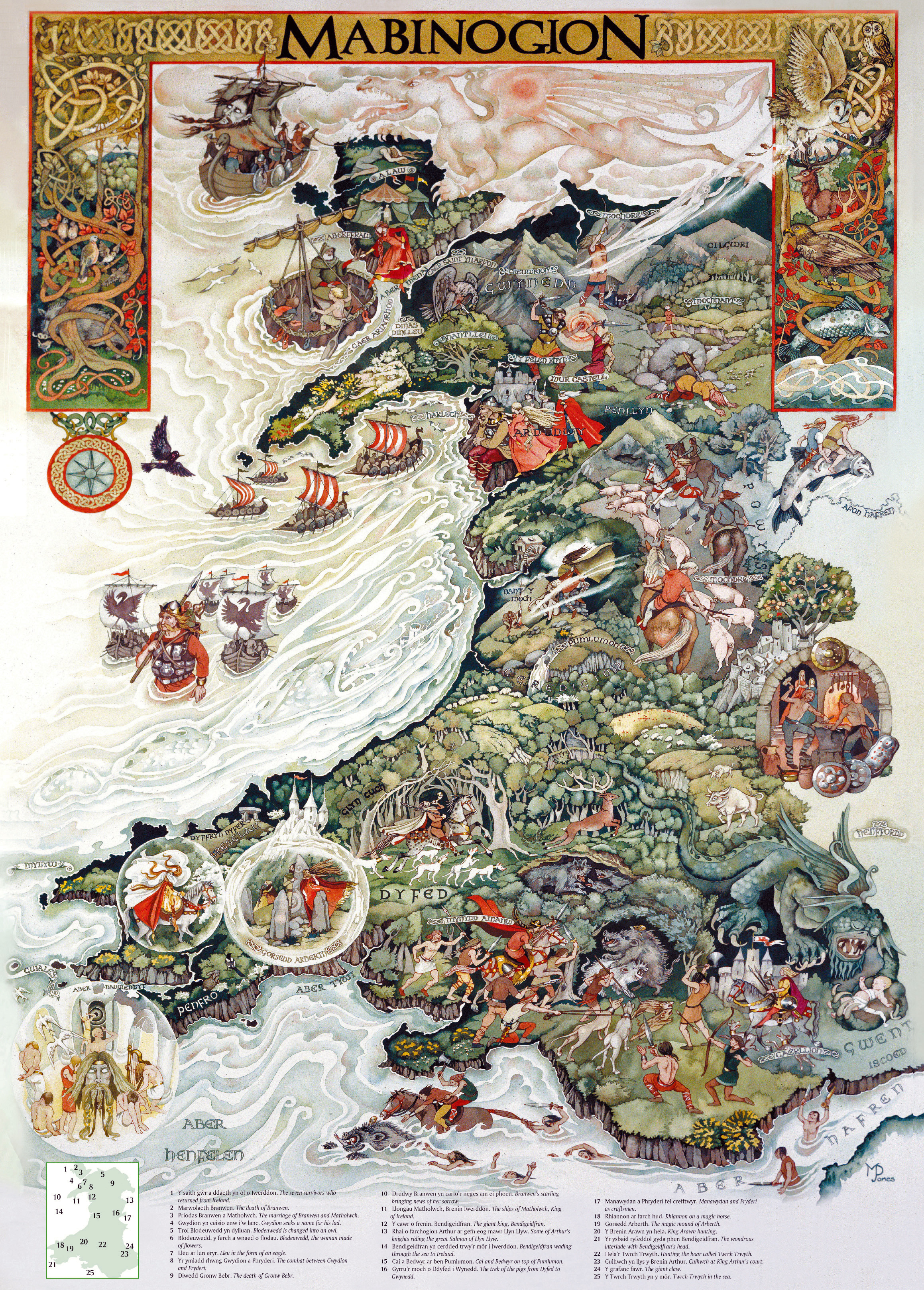
(Really) Old-School Map of Wales:
Re: The Unusual Maps Thread
Posted: Fri May 11, 2018 12:42 am
by Pat the Ex Mat
I lived above, and went to school in Nantlle Valley - where the eagle is.
It's the valley on the far left, with a lake here:

Re: The Unusual Maps Thread
Posted: Tue May 15, 2018 3:48 am
by Nieghorn
Interactive maps of the locations mentioned in The Odyssey
http://esripm.maps.arcgis.com/apps/MapT ... acf3dd1b3e
Re: The Unusual Maps Thread
Posted: Thu May 17, 2018 10:57 pm
by Doc Rob
Pat the Ex Mat wrote:The No response for North Wales should of course be:
"Chips a Cwri saws"
Saws Cwri, I suspect.
The Welsh for chips is ‘Sglodion’ but in nearly 10 years I have yet to hear anyone say it. ‘Fish & Chips’ is so much easier to say than ‘Pysgod a Sglodion’. People invariably give phone numbers in English for the same reason.
Re: The Unusual Maps Thread
Posted: Thu May 17, 2018 11:05 pm
by etherman
Good find.
And connected, a series of approaches to mapping Leopold Blooms journey through Ulysses:
http://gorse.ie/ulysses-mapped/
Re: The Unusual Maps Thread
Posted: Fri May 18, 2018 1:16 am
by Pat the Ex Mat
Doc Rob wrote:Pat the Ex Mat wrote:The No response for North Wales should of course be:
"Chips a Cwri saws"
Saws Cwri, I suspect.
The Welsh for chips is ‘Sglodion’ but in nearly 10 years I have yet to hear anyone say it. ‘Fish & Chips’ is so much easier to say than ‘Pysgod a Sglodion’. People invariably give phone numbers in English for the same reason.
Nah, mine is correct - I spent more than 10 years ordering it in Caernarfon that way.
Nobody uses Sglodion.
It's also always Siop Chip.
Re: The Unusual Maps Thread
Posted: Tue May 22, 2018 10:39 pm
by Heymans
https://easyzoom.com/imageaccess/ec482e ... 156bb6836f
Very good trade map route. If someone manages to embedd it, please do.
Re: The Unusual Maps Thread
Posted: Wed May 23, 2018 1:31 am
by True Blue
Makes you wonder what the world would be like if the roman empire never collapsed. Very organized people. And sex perverts. The best of both worlds.
Re: The Unusual Maps Thread
Posted: Wed May 23, 2018 3:06 am
by WoodlandsRFC
True Blue wrote:
Makes you wonder what the world would be like if the roman empire never collapsed. Very organized people. And sex perverts. The best of both worlds.
If only Christianity hadn't taken ahold and those barbarians from the steppes hadn't decided they needed to use their superior tactics of war against a bunch of I'll disciplined mercenaries posing under a Roman split oligarchy. Rome made a habit of building roads absolutely straight, as a show of superiority, and also because it's technically the fastest way to get anywhere is in a straight line.
Re: The Unusual Maps Thread
Posted: Wed May 23, 2018 3:06 am
by maxbox
I am sure the church would be rife with peados
Oh wait
Re: The Unusual Maps Thread
Posted: Wed May 23, 2018 9:53 am
by Lacrobat
Re: The Unusual Maps Thread
Posted: Wed May 23, 2018 10:26 am
by backrow
True Blue wrote:
Makes you wonder what the world would be like if the roman empire never collapsed. Very organized people. And sex perverts. The best of both worlds.
It would have been white people only left on the planet , and only Christianity. Infrastructure would have been amazing, and all telly would have very hot women presenters.
Re: The Unusual Maps Thread
Posted: Fri May 25, 2018 1:18 am
by Taranaki Snapper
All of the Rulers of Europe Over the Past 2,400 Years Presented in a Timelapse Map (400 B.C. to 2017 A.D.)
(time-lapse video...)
http://www.openculture.com/2018/05/all- ... 7-a-d.html
Re: The Unusual Maps Thread
Posted: Fri May 25, 2018 1:59 am
by Lacrobat
Re: The Unusual Maps Thread
Posted: Fri May 25, 2018 2:00 am
by Lacrobat
Re: The Unusual Maps Thread
Posted: Thu May 31, 2018 1:14 am
by Taranaki Snapper
Watch the Rise and Fall of the British Empire in an Animated Time-Lapse Map ( 519 A.D. to 2014 A.D.)
http://www.openculture.com/2018/05/watc ... 014-d.html
Re: The Unusual Maps Thread
Posted: Sat Jun 02, 2018 1:56 am
by Lacrobat
Re: The Unusual Maps Thread
Posted: Mon Jun 04, 2018 5:11 pm
by Lacrobat
Behold - the mighty New Zealand Empire!
Re: The Unusual Maps Thread
Posted: Mon Jun 04, 2018 5:14 pm
by Lacrobat
250 Million AD - New Zealand, still doing its own thing...

Re: The Unusual Maps Thread
Posted: Sun Jun 10, 2018 1:17 am
by Lacrobat
Re: The Unusual Maps Thread
Posted: Mon Jun 11, 2018 5:50 am
by Taranaki Snapper
More people live INSIDE the highlighted 5,000 mi/8,000 km circle than live OUTSIDE it.

Re: The Unusual Maps Thread
Posted: Mon Jun 11, 2018 1:02 pm
by Taranaki Snapper
A map drawn by an Indigenous guide for Lewis and Clark, recently discovered in the Bibliothèque Nationale de France, is the subject of an entire issue of the Lewis and Clark Trail Heritage Foundation’s journal, We Proceeded On. (The issue is not available online.) The map was drawn some time in 1805 by Too Né, a member of the Arikara tribe who in 1804 travelled with the Lewis and Clark expedition in what is now North Dakota, and shows the extent of the territory known to the Arikara at that time.
 http://www.maproomblog.com/2018/05/too- ... and-clark/
Re: The Unusual Maps Thread
Posted: Tue Jun 12, 2018 7:48 am
by kiap
Re: The Unusual Maps Thread
Posted: Fri Jun 15, 2018 1:02 am
by Lacrobat
Re: The Unusual Maps Thread
Posted: Fri Jun 15, 2018 1:03 am
by Lacrobat
BTW, for map nerds - fill yer boots, thank me later:
http://dinosaurpictures.org/ancient-earth#240
Re: The Unusual Maps Thread
Posted: Fri Jun 15, 2018 1:31 am
by Pat the Ex Mat
Lacrobat wrote:
What was the area that is densely populated in the north, moving south-west?
Re: The Unusual Maps Thread
Posted: Fri Jun 15, 2018 1:50 am
by Taranaki Snapper
Pat the Ex Mat wrote:Lacrobat wrote:
What was the area that is densely populated in the north, moving south-west?
Something to do with the Ulster Plantation?