Page 46 of 46
Re: The Unusual Maps Thread
Posted: Tue Aug 04, 2020 11:57 am
by Farva
Not so much a map but a video but it’s pretty cool. Video of London pre great fire.
Six students from De Montfort University have created a stellar 3D representation of 17th century London, as it existed before The Great Fire of 1666. The three-minute video provides a realistic animation of Tudor London, and particularly a section called Pudding Lane where the fire started. As Londonist notes, "Although most of the buildings are conjectural, the students used a realistic street pattern [taken from historical maps] and even included the hanging signs of genuine inns and businesses" mentioned in diaries from the period.
For their efforts, the De Montfort team was awarded first prize in the Off the Map contest, a competition run by The British Library and video game developers GameCity and Crytek.
http://www.openculture.com/2013/11/fly- ... 3NIdIPbVVY
Re: The Unusual Maps Thread
Posted: Tue Aug 04, 2020 12:33 pm
by kiap
Farva wrote:Not so much a map but a video but it’s pretty cool. Video of London pre great fire.

It's well done, but ye old city doesn't look real pretty on today's measure.
With all that wood you can see why it burned down as well.
Re: The Unusual Maps Thread
Posted: Tue Aug 04, 2020 12:53 pm
by mdaclarke
Farva wrote:Not so much a map but a video but it’s pretty cool. Video of London pre great fire.
Six students from De Montfort University have created a stellar 3D representation of 17th century London, as it existed before The Great Fire of 1666. The three-minute video provides a realistic animation of Tudor London, and particularly a section called Pudding Lane where the fire started. As Londonist notes, "Although most of the buildings are conjectural, the students used a realistic street pattern [taken from historical maps] and even included the hanging signs of genuine inns and businesses" mentioned in diaries from the period.
For their efforts, the De Montfort team was awarded first prize in the Off the Map contest, a competition run by The British Library and video game developers GameCity and Crytek.
http://www.openculture.com/2013/11/fly- ... 3NIdIPbVVY
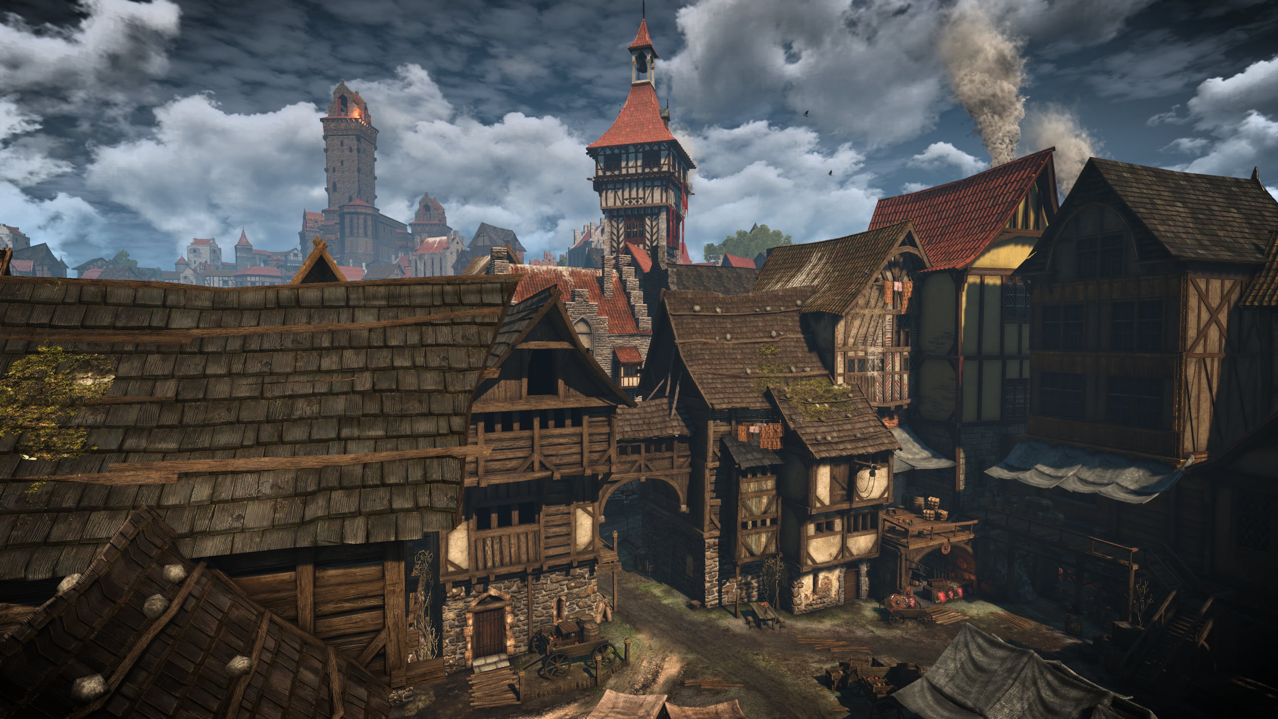
Reminds me of Ankh-Morpork
Re: The Unusual Maps Thread
Posted: Tue Aug 04, 2020 2:47 pm
by Nolanator
mdaclarke wrote:Reminds me of Ankh-Morpork
Well that is the inspiration for A-M, so makes sense!
Serious vibe of Novigrad from the Witcher 3, as well
Re: The Unusual Maps Thread
Posted: Tue Sep 08, 2020 5:33 am
by kiap
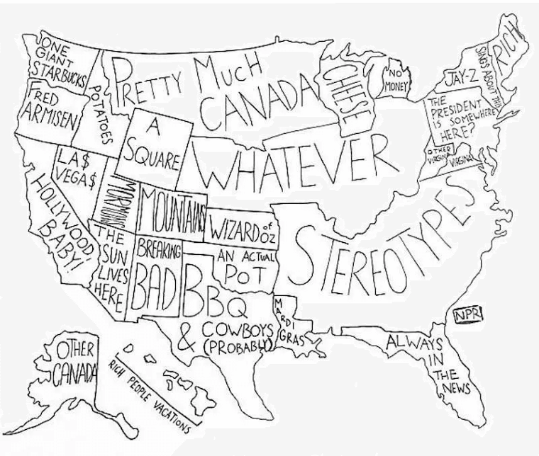
Land use US:

Re: The Unusual Maps Thread
Posted: Tue Sep 08, 2020 3:58 pm
by Flyin Ryan
kiap wrote: ↑Tue Sep 08, 2020 5:33 am
Land use US:
Missing Alaska and Hawaii.
Re: The Unusual Maps Thread
Posted: Tue Sep 08, 2020 4:13 pm
by puku
Flyin Ryan wrote: ↑Tue Sep 08, 2020 3:58 pm
kiap wrote: ↑Tue Sep 08, 2020 5:33 am
Land use US:
Missing Alaska and Hawaii.
And Iowa, Minnesota and at least half of Nebraska are cropland not pasture/range/cow. There are other issues too.
Re: The Unusual Maps Thread
Posted: Tue Sep 08, 2020 6:25 pm
by Fruit and Nutt
Lacrobat wrote: ↑Sat Jun 27, 2020 5:05 pm
The oldest continuously-operated restaurants in the world. Well-played The Gables in Russell, NZ:
I suspect the term 'continuously operated' has the same meaning as 'Trigger's Broom'.
Re: The Unusual Maps Thread
Posted: Tue Sep 08, 2020 7:50 pm
by Flyin Ryan
puku wrote: ↑Tue Sep 08, 2020 4:13 pm
Flyin Ryan wrote: ↑Tue Sep 08, 2020 3:58 pm
kiap wrote: ↑Tue Sep 08, 2020 5:33 am
Land use US:
Missing Alaska and Hawaii.
And Iowa, Minnesota and at least half of Nebraska are cropland not pasture/range/cow. There are other issues too.
Well the map is taking the lower 48's land mass and making a map of it based on percentage use. It doesn't matter where the bits of it are as the bits have little geographical meaning. But removing Alaska which is the largest state means in reality that every section on the map should be larger than what is shown (i.e. take the size of everything shown and multiply it by 1.21). The problem probably has to deal with scaling because maps showing the country plus Alaska and Hawaii, Alaska is always scaled significantly downward in size.
Re: The Unusual Maps Thread
Posted: Tue Sep 08, 2020 7:58 pm
by lilyw
Flyin Ryan wrote: ↑Tue Sep 08, 2020 7:50 pm
puku wrote: ↑Tue Sep 08, 2020 4:13 pm
Flyin Ryan wrote: ↑Tue Sep 08, 2020 3:58 pm
kiap wrote: ↑Tue Sep 08, 2020 5:33 am
Land use US:
Missing Alaska and Hawaii.
And Iowa, Minnesota and at least half of Nebraska are cropland not pasture/range/cow. There are other issues too.
Well the map is taking the lower 48's land mass and making a map of it based on percentage use. It doesn't matter where the bits of it are as the bits have little geographical meaning. But removing Alaska which is the largest state means in reality that every section on the map should be larger than what is shown (i.e. take the size of everything shown and multiply it by 1.21). The problem probably has to deal with scaling because maps showing the country plus Alaska and Hawaii, Alaska is always scaled significantly downward in size.
Edited for stupidity.
Re: The Unusual Maps Thread
Posted: Thu Sep 10, 2020 6:05 am
by kiap
 I'm sure NZ has some but they're not mentioned.
Re: The Unusual Maps Thread
Posted: Mon Sep 21, 2020 12:57 am
by paddyor
Re: The Unusual Maps Thread
Posted: Mon Sep 21, 2020 10:02 am
by Nolanator
Mexican billionaires seem to have the most indivicual wealth by far.
Bunch of El Chapo's mates?
Re: The Unusual Maps Thread
Posted: Mon Sep 21, 2020 2:35 pm
by ZappaMan
Nolanator wrote: ↑Mon Sep 21, 2020 10:02 am
Mexican billionaires seem to have the most indivicual wealth by far.
Bunch of El Chapo's mates?
Carlos Slim would be worth $50bn+ so would distort the Mexican figures somewhat.
Re: The Unusual Maps Thread
Posted: Mon Sep 21, 2020 4:38 pm
by Nolanator
ZappaMan wrote: ↑Mon Sep 21, 2020 2:35 pm
Nolanator wrote: ↑Mon Sep 21, 2020 10:02 am
Mexican billionaires seem to have the most indivicual wealth by far.
Bunch of El Chapo's mates?
Carlos Slim would be worth $50bn+ so would distort the Mexican figures somewhat.
Actually, looking at it they seem to have just divided the total wealth held by billionaires by the number of billionaires. It's evenly distributed. Be more intersting if the circles within a country were of different sizes. Probably get to likes of Slim, Bezos, Gates etc massively distorting things.
Re: The Unusual Maps Thread
Posted: Tue Sep 22, 2020 2:47 am
by Flyin Ryan
Nolanator wrote: ↑Mon Sep 21, 2020 10:02 am
Mexican billionaires seem to have the most indivicual wealth by far.
Bunch of El Chapo's mates?
Mexico has the rich, the poor, and little in the middle. The country collapsed economically in the early '90s and has never really recovered.
Re: The Unusual Maps Thread
Posted: Tue Sep 22, 2020 9:24 am
by Taranaki Snapper
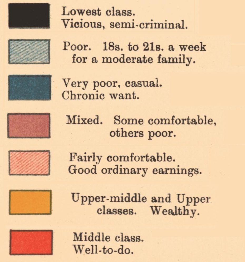
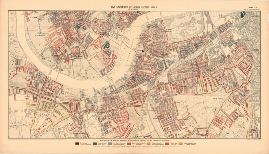
The Maps Descriptive of London Poverty are perhaps the most distinctive product of Charles Booth's Inquiry into Life and Labour In London (1886 - 1903). An early example of social cartography, each street is coloured to indicate the income and social class of its inhabitants.
https://www.flickr.com/photos/lselibrar ... 8449873093
Re: The Unusual Maps Thread
Posted: Fri Nov 20, 2020 11:07 am
by Taranaki Snapper
Average female breast size in Europe based on cup size
Re: The Unusual Maps Thread
Posted: Fri Nov 20, 2020 12:12 pm
by backrow
Taranaki Snapper wrote: ↑Fri Nov 20, 2020 11:07 am
Average female breast size in Europe based on cup size
Prob says which countries buy ill fitting clothes - this is a subject I have researched and sadly there is no real correlation between country and bangers size. Very loosely , the fatter blonder countries like Ireland , uk, Germany , will have bigger tits than svelte darker French and Italian and Spanish laydeez, but that’s are far as it goes.
Tits

Re: The Unusual Maps Thread
Posted: Mon Feb 15, 2021 12:16 pm
by Taranaki Snapper
Re: The Unusual Maps Thread
Posted: Mon Feb 15, 2021 7:16 pm
by puku
Fascinating.
Re: The Unusual Maps Thread
Posted: Fri Apr 09, 2021 12:26 am
by Taranaki Snapper
Re: The Unusual Maps Thread
Posted: Sun Apr 25, 2021 7:35 am
by Taranaki Snapper
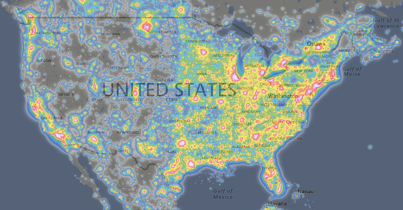
Light pollution map is exactly as promised, and works like Google Earth: scroll, zoom and bring up various different datasets and legends to make sense of it all. I'm always stuck by that dead-straight transition between light and dark in North America, from Winnipeg to Austin. That mystery metropolis in North Dakota? Oilfields!
https://boingboing.net/2021/04/23/light ... world.html
https://www.lightpollutionmap.info/#zoo ... FFFFFFFFFF
Re: The Unusual Maps Thread
Posted: Sun Apr 25, 2021 12:57 pm
by RuggaBugga
Was wondering what that was
Re: The Unusual Maps Thread
Posted: Sun Jun 20, 2021 4:14 am
by Flyin Ryan
Double post
Re: The Unusual Maps Thread
Posted: Sun Jun 20, 2021 4:18 am
by Flyin Ryan
Re: The Unusual Maps Thread
Posted: Tue Sep 21, 2021 5:43 am
by sonic_attack
Not really a map, but an animated visualisation of the planets orbit in relation to earth.
https://www.youtube.com/watch?v=vU-g6mC1F0g
Re: The Unusual Maps Thread
Posted: Thu Nov 04, 2021 11:00 am
by Taranaki Snapper
35 History Maps That Will Make You See The World In A Whole New Light
https://allthatsinteresting.com/history-maps
Re: The Unusual Maps Thread
Posted: Thu Nov 04, 2021 3:37 pm
by Nickdemus
Farva wrote: ↑Tue Mar 26, 2019 9:57 am
Rinkals wrote:Lacrobat wrote:FYI:
Eh?
You can drink tap water in most of South Africa, Namibia and Botswana.
You
can drink tap water almost anywhere. It doesnt mean you should!
Been drinking tap water my whole life in Africa.
Re: The Unusual Maps Thread
Posted: Thu Nov 04, 2021 3:53 pm
by backrow
Taranaki Snapper wrote: ↑Tue Sep 22, 2020 9:24 am
The Maps Descriptive of London Poverty are perhaps the most distinctive product of Charles Booth's Inquiry into Life and Labour In London (1886 - 1903). An early example of social cartography, each street is coloured to indicate the income and social class of its inhabitants.
https://www.flickr.com/photos/lselibrar ... 8449873093
It’s a good thing the black areas of London are no longer those with the most crime
Re: The Unusual Maps Thread
Posted: Fri Nov 05, 2021 7:24 am
by Taranaki Snapper
[quote="backrow
It’s a good thing the black areas of London are no longer those with the most crime
[/quote]
Edgy...or edging...
Re: The Unusual Maps Thread
Posted: Thu Jan 13, 2022 3:15 am
by Taranaki Snapper
Favorite Maps of 2021
Over on Cartoblography, Kenneth Field has published his annual look at his favorite maps from the past year. His list includes Stamen 2020 Headquarters by Catalina Plé, 500,000 lives lost by NBC News, Population change by US state since 2010 by Adrian Blanco and Tim Meko at The Washington Post, Global Glacier Loss by Niko Kommenda, San Marino Bus Map by Jug Cerovic, It’s Coming Home by Dan, Algonquin Canoe Trip by Warren Davison, Tokyo Olympics Opening Ceremony Drone Globe, Atlas of the Invisible by James Cheshire and Oliver Uberti, St. Vincent Island by Aaron Koelker, Arctic Warming by Greg Fiske, The Lost Treasures of Isla del Coco by Jakob Listabarth, and Murky Waters by Andrew Douglas Clifford.
https://www.metafilter.com/193948/Favorite-Maps-of-2021
Re: The Unusual Maps Thread
Posted: Sat Nov 19, 2022 9:31 am
by Jensrsa
Re: The Unusual Maps Thread
Posted: Sat Nov 19, 2022 2:54 pm
by Ramming Speed
Taranaki Snapper wrote: ↑Fri Nov 20, 2020 11:07 am
Average female breast size in Europe based on cup size
I finally understand why Belarus won’t break away from Russia.
Re: The Unusual Maps Thread
Posted: Wed Feb 15, 2023 1:28 pm
by Newsome
Sorry mum, you're on your own.

Re: The Unusual Maps Thread
Posted: Fri Oct 13, 2023 2:47 am
by mabunch78
Maybe not unusual but...

I know it's driven a little bit by paranoia but there are plenty of England fans across any sport who would suggest it always feels as though you could swap out Fiji for whichever is the next opponent and this map wouldn't change.